
Note
Go to the end to download the full example code.
Divergence (Spherical Harmonics)
Horizontal divergence measures the horizontal outflow or inflow of the wind field.
This example uses
easyclimate.spec.calc_divergence
and its Rust-backed counterpart
easyclimate.spec.calc_divergence_rs
on a single pressure-level wind field.
import cartopy.crs as ccrs
import xarray as xr
import matplotlib.pyplot as plt
import easyclimate as ecl
Open the tutorial zonal and meridional wind components, combine them into one dataset, and select one 500 hPa time slice for the calculation.
u_data = ecl.open_tutorial_dataset("uwnd_2022_day5").uwnd
v_data = ecl.open_tutorial_dataset("vwnd_2022_day5").vwnd

uvdata = xr.Dataset()
uvdata["uwnd"] = u_data
uvdata["vwnd"] = v_data

uvdata_500_202201 = uvdata.sel(level=500).isel(time = 3)
uvdata_500_202201
Prepare a scientific-notation formatter for the colorbars. Many spectral wind diagnostics have small physical units, so this keeps the labels readable.
import matplotlib.ticker as ticker
formatter = ticker.ScalarFormatter(useMathText=True, useOffset=True)
formatter.set_scientific(True)
formatter.set_powerlimits((0, 0))
The result is an xarray.DataArray on the original latitude-longitude grid.
div_fp = ecl.spec.calc_divergence(
    u_data=uvdata_500_202201["uwnd"],
    v_data=uvdata_500_202201["vwnd"],
)

div_rs = ecl.spec.calc_divergence_rs(
    u_data=uvdata_500_202201["uwnd"],
    v_data=uvdata_500_202201["vwnd"],
)
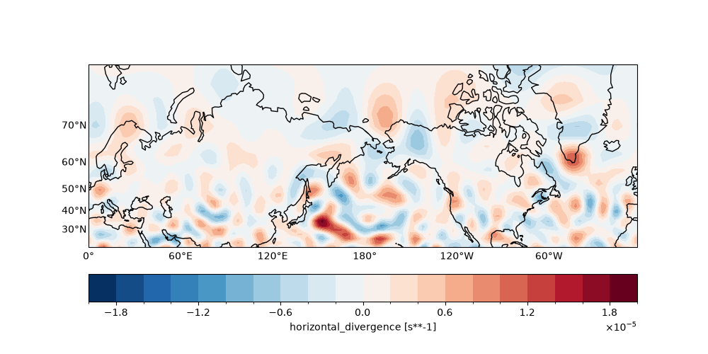
The first plot shows the Fortran-backed divergence field on a map projection over the Northern Hemisphere mid-to-high latitudes.
fig, ax = plt.subplots(
    figsize = (10, 5),
    subplot_kw={"projection": ccrs.Mercator(central_longitude=180)}
)
ax.coastlines()
ax.gridlines(crs=ccrs.PlateCarree(), draw_labels=["bottom", "left"], alpha = 0)

div_fp.sortby("lat").sel(lat=slice(20, 80)).plot.contourf(
    levels=21,
    cbar_kwargs = {'location': 'bottom', 'format': formatter, 'pad': 0.1},
    transform = ccrs.PlateCarree(),
)
<cartopy.mpl.contour.GeoContourSet object at 0x73ce95517da0>
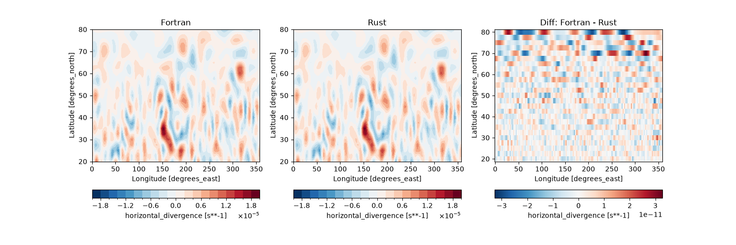
The final panel compares Fortran, Rust, and their difference. This is useful when validating backend consistency for the same input field.
fig, ax = plt.subplots(1, 3, figsize = (15, 5))

div_fp.sortby("lat").sel(lat=slice(20, 80)).plot.contourf(
    levels=21,
    ax = ax[0],
    cbar_kwargs = {'location': 'bottom', 'format': formatter},
)
ax[0].set_title("Fortran")

div_rs.sortby("lat").sel(lat=slice(20, 80)).plot.contourf(
    levels=21,
    ax = ax[1],
    cbar_kwargs = {'location': 'bottom', 'format': formatter},
)
ax[1].set_title("Rust")

(div_fp - div_rs).sortby("lat").sel(lat=slice(20, 80)).plot(
    ax = ax[2],
    cbar_kwargs = {'location': 'bottom'},
)
ax[2].set_title("Diff: Fortran - Rust")
Text(0.5, 1.0, 'Diff: Fortran - Rust')
Total running time of the script: (0 minutes 9.234 seconds)